Smoky Cape
Grade 4: Another distinctive land feature in unspoiled surroundings with impressive coastal views.
Situation: About 16 kms north east of Kempsey, New South Wales, in Hat Hill National Park.
Coordinates (decimal): 30.92 S 153.10 E
Endeavour Journal – 13 May 1770:
At noon we were by observation in the Latitude of 30.43 S and Longde 206.45 west and about 3 or 4 Leagues from the land, the northermost part of which bore from us N 13 West and a point or headland on which were fires that caused a great quantity of smook which occasioned my giving it the name of smooky Cape, bore SW distant 4 Leagues. It is moderatly high land, over the pitch of the point is a round hillock, within it two others much higher and larger [Big Smoky 311m, and Little Smoky 210m] and within them very low land Latitude 30.51 S, longitude 206.54 West. Besides the smook seen upon this Cape we saw more in several places along the Coast.
To the left of the car park at Smoky Cape is a picnic area with a plaque commemorating Cook’s naming, and Captain Cook’s Lookout, above is a lighthouse. Cook’s sparse description of the area is, as usual, accurate in every respect. To the south Cook’s distant North Brother can be seen. Indeed the whole coast from Port Stephens to beyond Smoky Cape, nearly 200 km, can be seen from Tomaree (Port Stephens), Cape Hawke and North Brother.
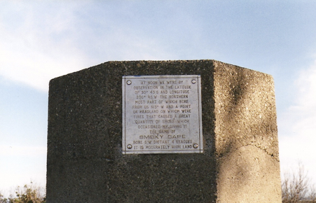
Commemorative Plaque at Smoky Cape
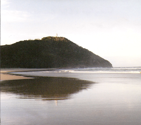
Smoky Cape with lighthouse from the south
The following day, 14 May 1770, Endeavour’s Journal records:
At noon we were about4 Leagues from the land and by observation in the latitude of 30.22 S… Some tolerable high land near the shore bore west.
These are the ranges inland from Coffs Harbour and Sawtell (Dorrigo escarpment), visible from the Pacific Highway.